
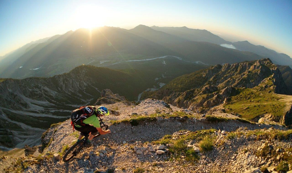
My passion is Mountainbiking. That’s why I spent every last minute of late summer days enjoying nature on my bike, absorbing that sweet adrenalin. Me and my buddies from our Flow Valley Crew get out there every free second of our time and explore the most spectacular Bavarian Alpine Trails on our bikes.
If you would also like to explore the mountains on your bike, accompanied by some the crispy fall weather, here you can find a couple of tips I have prepared for you. You can feel the thrill and action in the Ammergau Alps, Wetterstein Mountains, in Isarwinkel, Allgäu or Chiemgau. And according to your abilities, you can choose between easy, medium and hard trails.
Have fun and enjoy your ride 😉
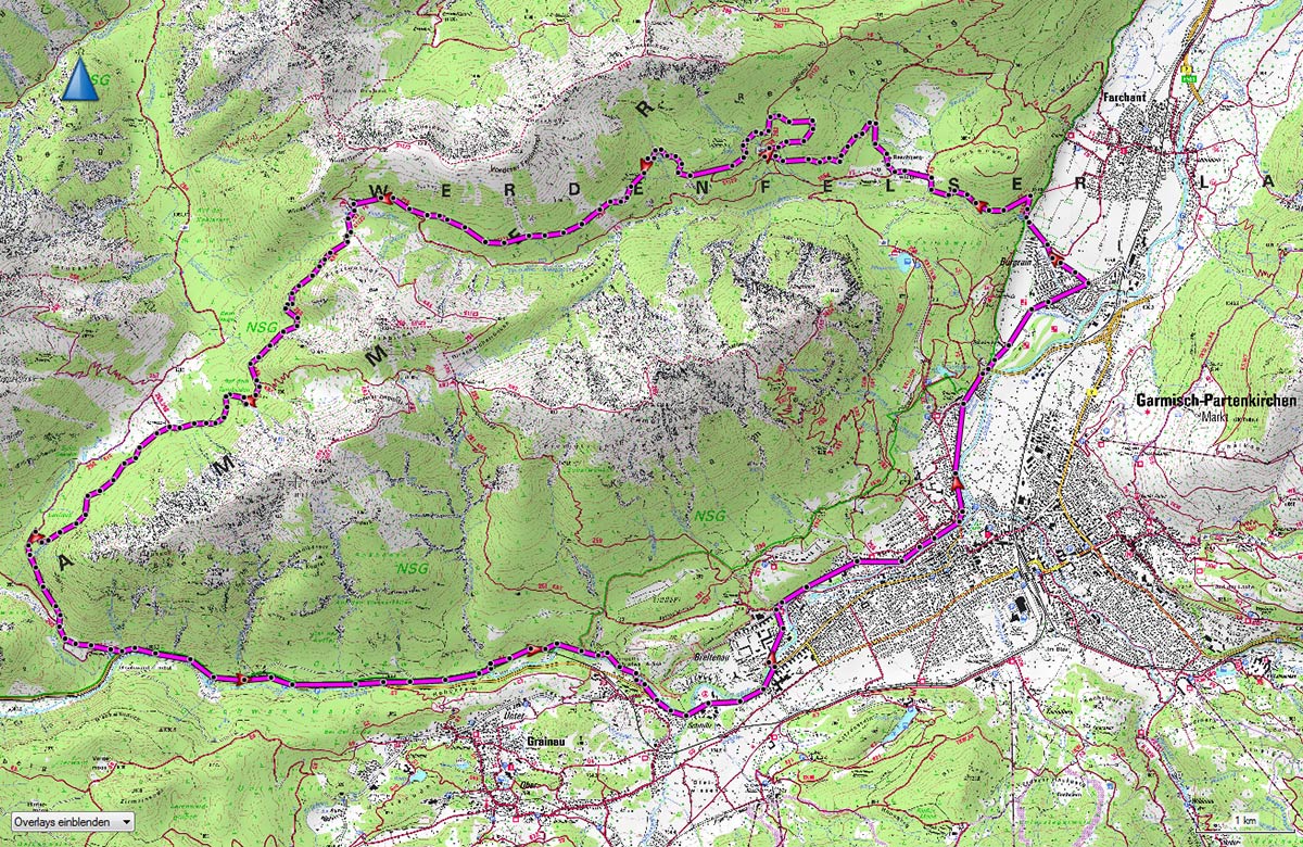
Mountainbike TOUR 1 – KRAMER ROUNDTOUR in AMMERGAU ALPS – A CLASSIC
Longing for some fresh air? Here you go! This tour in the Ammergau Alps is considered as a classic one with lovely descent. During longer summer days, accompanied by eBike, you can make this your after-work evening round.
Details:
- Elevation gain: about 900m
- Distance: 19,5 miles
- Condition: low – medium
- Technical difficulty: easy – medium
- Arrival: From Munich via the Autobahn A95 direction Garmisch-Partenkirchen, and further on B2 through Farchant to Burgrain. At the beginning of Burgrain, turn right to Feldernkopfstraße, where you can find a parking lot at the end of the street.
- Starting Point: parking lot for hikers in Burgrain
- Others: Accessible via public transport
Starting from the parking lot you will take the forest road up, direction Reschbergwisen. In the middle of the nice meadow follow the sign to Enningalm towards the right. Crank up on the wide road all the way to its highest point. After a short descent turn right on the road, direction Enningalm (by the big information table of Bavarian Saatsforsten). Shift up to your highest gear and work your way up on the steep platform. After that, just in a couple of meters, follow the hiking path to Enningalm.
For the good rides the fun begins now. From Enningalm thought the Hut area, ride in the direction Krottenköpfel (South). Turn right on the fork towards Linderhof. From there on you will find yourself on a funny, and easy to ride hiking path with many switchbacks turns, leading you to Rotmossalm. By the Rotmossalm stay left, and follow the path on the edge of the woods. On all the possible forks keep yourself right and after a steeper part, come a forest road turning to the left. After that, there is just a comfy path all the way to Garmisch where you can roll back to the parking lot in Burgrain.

mountainbike TOUR 2 – REINTALANGER HUT in the WETTERSTEIN massif – STUNNING LANDSCAPE
An impressive bike tour alongside of the massive northern walls of the Hochwanner Mountain. You might plan a day for this tour and enjoy the scenic views – adventurous trails inclusive!
Details:
- Elevation gain: about 1100m
- Distance: about 24 miles
- Condition: medium – high
- Technical difficulty: medium
- Arrival: From Munich via the Autobahn A95 to Garmisch-Partenkirchen, through the town on B2 direction Mittenwald. At the end of the town, turn right and follow the shield leading you to the Olympic Stadium parking lot
- Starting point: parking lot of the Olympic Stadium
- Others: accessible via public transport, very rich on panoramic views
From the parking lot follow the street up in the direction Partnach gorge, on the first fork take right and follow the shield for Partnach-Alm. Follow the path along Laub Hut and Mitterklamm all the way Bad Heilbrunn to the height of Hinterklamm on a nice and relatively flat trail along the Partnach River leading to the Bock Hut. From there take the narrow path which is going steadily up to the Reihntalager Hut (1369 m) at the end of the valley.
The descent goas the same way down as you went up, until you are back at the Mitterklamm. From there take the upper road along the Partnach River almost to the entrance of the Partnach Gorge. Follow the Ferchenbach Creek in the direction Elmau for ca. 3,7 km and then turn left direction Hintergraseck. There you can await a steeper road going over Hinter and Vordergraseck around Wildenau all the way back to Olympic Stadium.


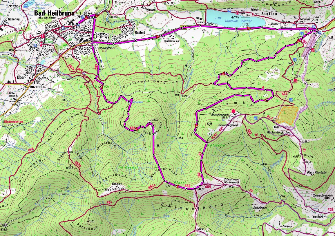
mountainbike TOUR 3 – ZWIESEL in ISARWINKEL – Challenging TRAIL EXPERIENCE
An easily accessible but demanding trail tour in the Voralps with peak adventure – awesome as a quick evening round.
Details:
- Elevation gain: about 700m
- Distance: about 7.4 miles
- Condition: low
- Technical difficulty: hard
- Arrival: From Munich via the Autobahn A8 direction Salzburg. Take the exit Holzkirchen and follow B13 through Bad Tölz to Bad Heilbrunn
- Starting point: Parking lot of the Sportheim in bad Heilbrunn
- Others: better know your skills and technique well for those demanding singletrails
Starting from the parking lot, follow the bike-route along the B472 to the large parking lot of the Blombergbahn. From there follow the forest road uphill in the direction Blomberg. Right before reaching the peak of Blomberg turn right onto the hiking trail (a little brighter) in the direction Zwiesel (1348 m). From here on push (carry) your bike for the rest of the trail all the way to the peak of the Zwiesel.
From here descent in the west direction on the trail through the meadows over the Stallauer Kopf (1322 m) and the Stallauer Eck (1213 m) towards the town of Bad Heilbrunn. As soon as you reach the forest road, keep left and after that turn right on the following path. You will cross the forest road once again and follow the trail all the way down back to Bad Heilbrunn.

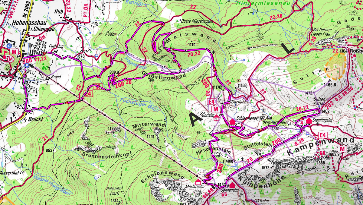
mountainbike TOUR 4 – KAMPENWAND in CHIEMGAU – BEAUTiFUL TOUR, pERFECt for beginners
An amazing tour above the crystal clear waters of Chiemsee Lake, also perfect for beginner riders.
Details:
- Elevation gain: about 800m
- Distance: about 8.5 miles
- Condition: medium
- Technical difficulty: easy – medium
- Arrival: From Munich via the Autobahn A8 direction Salzburg. Take the exit Frasdorf and follow the road to Aschau, where you can stop on the Kampenwandbahn parking lot.
- Starting point: Parking lot of the Kampenwandbahn
- Others: Indefinite possibilities for panoramic stops
Follow the road uphill, starting from the parking lot and around the cable car. You will meet the first junction in the forest, there you go left in the direction Gorialm Hut/Steinlingalm Hut. Passing the Gorialm Hut take the last path and serpentines all the way to Steinlingalm Hut. From there take the hiking path leading you to the top station of the cable car in almost 1500 meters above the sea level.
Follow the path going down underneath the cable car in the direction of Gorialm Hut. From there on for 1,4 km follow the approach trail back (or alternatively keep left around the Gorialm Hut to detour on a demanding forest road), in the woods keep left on the old bridleway. Now follow the forest road and keep left all the way to Brückl. From Brückl you can take the street and you will get back to the parking lot just in a couple of minutes.

mountainbike TOUR 5 – ROUND AROUND THE SÄULING in ALLGÄU – PANORAMa TRIP WITH A COOL ENDING
Lengthy round in the Allmergau Mountains with a shorter trail descent – don’t let the masses of people around the Neuschweinstein Castle scare you away: the peace is waiting for you past the Marienbrücke Bridge.
Details:
- Elevation gain: about 1300m
- Distance: about 29 miles
- Condition: hard
- Technical difficulty: medium
- Arrival: From Munich via the Autobahn A96 to A7. Exit to the B16 and after that to B17 direction Füssen
- Starting point: Parking lot by the tourist info point
- Others: Panoramatic round with a possibility to take a short swim in the Plansee
From the tourist info point in Füssen, take the road direction Schwangau. Then comes the bike bridge (parallel to the König-Ludwig bridge) cross the Lech River – and then right towards Hohenschwangau. Past the bus stop underneath the Marienbrücke Bridge connect onto the Bleckenaustraße in Bleckenau and follow it to the Jägerhütte Hut. Take the Schützensteig-Trail ascending to the Alpenhotel Ammerwald and further on direction Plansee – a perfect stop for a break with a possibility to dip in the fresh water of Plansee.
After that, you need to go back for about 500 m and keep left on the Altenbergweg in the direction of Kuhklausee upways. Between Kuhklausee and Urisee you have to carry your bike for a little bit in the gorge. Then from Pflach through the Kniepass to Schluxen before you can roll down the Fürstenstraße on the shore of the Alpsee in the direction Hohenschwangau and back to Füssen.


Photo credit: © Flow Valley Team